Title: Songwe River to Kigali (Rwanda)

Dates: 27th May to 8th June GPS:

Distance: 1385km Total Distance: 17,068km

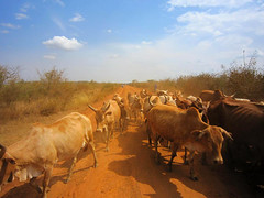
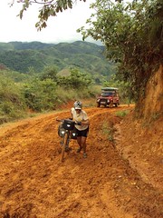
Roads: 873km gravel, sand; 512km tarmac – high mountains, long climbs, rolling hills in central Tanzania

Weather: high 20s, early 30s, prevailing easterly winds (cross winds)

1a. Climbing out of MbeyaFinally I have managed to draw a new route map which shows the first 17,000km of the journey. Please click on the adjacent icon to see an accurate representation of the route so far (up to Kigali). Entering Tanzania, we moved forward into another time zone – we’re now only 7 hours behind Eastern Standard Time in Australia (and just 5 hours behind WA). The first day in Tanzania was all about sucking in as much air as possible and absorbing a new culture as I cycled from about 500metres near Lake Malawi to 2300metres before dropping back to 1700metres at Mbeya. Initially the road ascended through some wild jungle-like terrain, away from the lake and into the low-level clouds. I saw two troops of monkeys beside the road and stopped to try to film some of them. This wasn’t that easy because they always try to hide by keeping leafy branches in their line of view.

1c. View from the pass

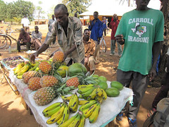
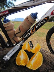
It started to rain heavily as I worked my way slowly up through some extensive tea plantations. Land use from then on became intensive with a variety of vegetables and fruit being grown on terraced plots and for sale beside the road. I was sodden by lunchtime (70km) and so John made soup to warm me up – and to go with the “Obama Buns” he had found in a small bakery. President Obama is a very popular man across Africa, but seems to be even more so as we near Kenya his country of birth. In Mali we saw “Obama” perfume in a store in the town of Nara. I’ve noted children wearing Obama t-shirts in most countries and we see Obama posters everywhere. The Obama buns were actually excellent – very sustaining.

1a. Climbing out of MbeyaNear the summit I met a German cyclist, Ingor – another tourist riding to the World Cup in South Africa. He didn’t think he would make it to the first match which he reminded me was against Australia. I reminded him not to be too cocky about the match… In Mbeya, John checked with truck drivers who had recently travelled or knew about the route we planned to take through to Tabora. The word generally seemed to be that it was passable for a LandRover, but not a two-wheel drive vehicle. We had been worried about all the rain we were having around Lake Malawi, but the lake creates its own weather pattern and the high mountains form a barrier to the weather. Once over the next huge pass out of Mbeya, we would enter a rain shadow – dropping down to the high central plains. We decided to go for it. The route would be much shorter and I was eager to venture along this little travelled road through central Tanzania.

I was looking forward to tackling the first obstacle – the high pass dividing Mbeya from Chunya – and had psyched myself accordingly. There was no warm up climb – it was simply straight up out of the town. I immediately dropped into the lowest range of gears. The path was extremely steep and stony, so it was a matter of focusing on just in front of the wheel to keep upright.

1b. Highest pass in Tanzania - should read 2466m!
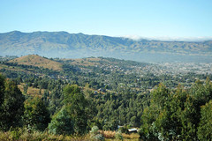
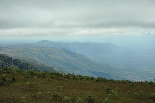
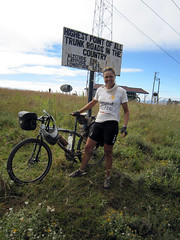
When I did have the opportunity to look up, the views were exceptional. Mbeya, one of Tanzania’s largest towns, gradually shrunk to appear as an insignificant mark within the immense scale of the valley. I felt extremely satisfied reaching the pass; a sign reminding me that it was the country’s highest trunk road. Whoever wrote the sign was about 500metres too generous with the altitude though, saying it was 2916metres rather than the 2466metres displayed on John’s GPS. The road then wound a convoluted path along a ridge, staying above 2000metres for at least 20km, before dropping down through some treacherous patches of bulldust and on to Chunya.

The following day was marred by slow punctures and a leaking oil seal on John’s rear axle and so we lost time attending to the breakdowns. Punctures are simple to fix, but the LandRover’s problem was potentially serious if John didn’t attend to it straight away. Replacing the seal was a fiddly job in the bush amongst accumulating numbers of sweat bees. Not too much time was lost however and I still clocked 106km, finishing in the dark.

4d. Cleaning teeth and eating fruit, KitundaSunday 30th May started alright and I enjoyed passing through a string of small villages. Then it all started to become heavy going as the path became sandy, especially along the low points. That wasn’t the worst of it though – just as I was struggling through deep sand I was bitten again and again by tsetse flies. Pretty soon a large angry swarm of tsetse hovered around and behind me. My clothes gave no protection. They could bite through my cycle shorts, shirt, gloves and socks. The bites are sharp and painful – sometime deep enough to draw blood. Give me the good ol’ Aussie fly any day. Australian bush flies are just annoying, and during my Australian expedition, once I generated some speed and brushed my shirt a few times I could lose them.

Tsetse however appear to be the athletes of the fly world. Even at 40km per hour, they would easily keep up – I could not lose them. John cycled out to meet me before the end of the first session and he too was attacked. They seemed to disappear in any inhabited area. When we stopped moving, they would soon lose interest and disappear. The trouble was that I had to cycle eight hours a day. For two days that meant I was continually attacked and found myself cycling faster and faster to try and get rid of them – to no avail.

3c.
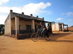
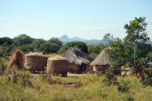
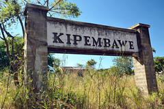
There were few villages marked on our map, but one was Kipembawe. We had expected to find the usual string of shops with little to buy and people milling around, chatting, selling from roadside stalls. Kipembawe was different though. It was completely dead – a ghost town. We never managed to confirm what we deduced from looking at the deserted buildings. A series of houses lined an overgrown street. They were solid well-made brick structures.

3b. Possibly a military outpost, built 1945
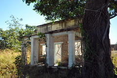
The date 1945 was painted on one facade and serial numbers branded each house. We think it was some sort of military outpost built at the end of the Second World War. By whom, we don’t know and no one seemed to know much about it. It was strange that it was deserted as usually in other places we have visited, locals would have moved into the houses or at least reuse all the materials.

5b. Taking desperate measures to keep out tetse flies
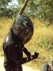
The tsetse problem worsened on second day. I started the day wearing a thick cotton long sleeved shirt which also protected my backside a little. They bit straight through that so I added a cycle jersey under it. The double layer of clothing worked, but they just concentrated on other body parts, especially my hands and the backs of my legs. Next I added a waterproof jacket and wrapped the shirt around my waist – a little better. Heading north from the remote village and mission of Kitunda, the problem worsened to a new level. I was travelling under a cloud of thousands of aggressive flies.

5a. Tetse flies on my bar bag. A difficult photo to take while cycling and being bitten constantly
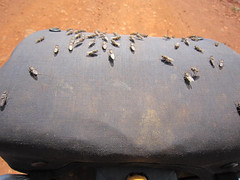
My barbag was coated with a thick mass of flies. (In the picture you see, I had tipped many of them off the barbag to retrieve my camera. I had to endure plenty of bites while I took the photo. John said that they would sit on the spare wheel of the vehicle and some would even keep speed as he drove, so he had to keep the windows closed. After lunch I resorted to desperate measures. My full suit of armour included; thick socks, double-lined track bottoms with a pair of cycle shorts over the top, cycle jersey and waterproof jacket, winter gloves, tape around my wrists because they kept finding the gap between glove and jacket, scarf, insect head net. It kept out the flies but was extremely hot. Nevertheless it was relief. There was a lot of sand and a few testing rough patches to endure too, but at least I could relax a little.

6b. Cycling through a herd of cows, Nzega to KahamaDespite the discomfort, we were travelling through a beautiful wild place with no people around – not even a car passed during the night. Setting off the next morning I was prepared for another battle with the tsetse, but it never eventuated. Just as fast as they descended upon us, they disappeared. I noted on the map that we had been travelling across the same latitude as when we encountered the tsetse in Angola, although the problem in Angola was only for about 40km and less intense than in Tanzania. About a kilometre from our campsite John noticed some lion footprints.

Tabora was a big friendly, relaxed African town. We enjoyed a day off there catching up on internet connections and bits and pieces. We’d been led to believe that that was the end of the rough unsealed road and so John switched tyres back to efficient road tyres. Six kilometres out of town however I was back on the dirt. It was heavy going for another day and a half before we finally rejoined the tarmac. Our next major concern was security between Kahama and the Rwandan border.

6c. Fruit seller, 15km from the tarmacEven a fellow in a small village, 15km before the bitumen warned that the region after Kahama was still full of refugees who fled from Burundi and Rwanda during and after the genocide. John quizzed a few truckies and learned that the real danger of being ambushed and robbed was after dark, so we proceeded with caution ensuring that we reached the safety of a hotel. This meant lopping off a couple of hours at days end to ensure we were set up before dark.

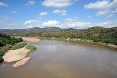
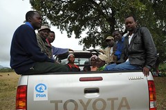
As we neared Rwanda, the land became very hilly and I was slowed up by a few long climbs. Rwanda is known as “Land of a Thousand Hills”, so I was expecting some hard work. Across the border at Rusumo (spectacular waterfall), many things changed dramatically. It was back to driving on the right hand side of the road. There were a lot more people. Rwanda is a tiny landlocked country with a population of 11 million. Rather than one cyclist joining me at a time, it was more like a peloton.

10a. Clean, landscaped streets in a village 40km into Rwanda from Rusumo

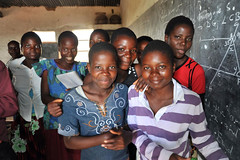
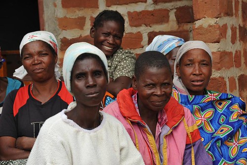
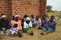
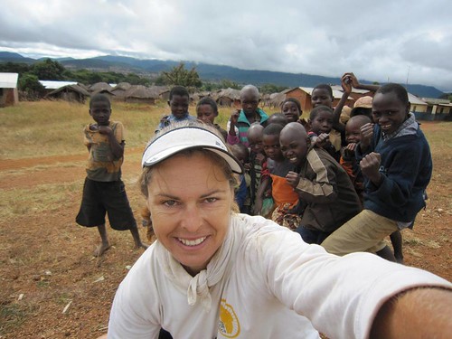
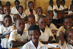
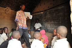
There were plenty of smiling faces and every time I stopped I was mobbed by a crowd of inquisitive children. There are no plastic bags in Rwanda and the streets are free of litter. Village main streets were clean and tidy with rubbish bins and gardens. There has been a lot of aid money pumped in to Rwanda to help citizens recover from the horrors of the genocide when at least two-thirds of the population were displaced and one million killed.

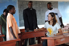
We made good time to reach Kigali a day early. Zdenek flew in on 9th June to rejoin the expedition. Our main goals were to visit the Millennium Village of Mayange, just south of the beautiful city and learn more about the genocide and how the nation is coping 16 years on.

{ 6 comments }

Malawi

by Kate on June 7, 2010

Title: Lilongwe to Songwe River (Malawi – Tanzania border)

Dates: 20th to 26th May GPS:

Distance: 662km Total Distance: 15,683km

Roads: Good tarmac except 90km rough unsealed, mud Rumphi to Livingstonia

Weather: Perfect! Mid-high 20s, cooler nights in mountains

1a. Meeting with Mr Wona, , Globe Metals headquarters, LilongweJohn and I had a day’s pit stop staying at the headquarters of Globe Metals and Mining in Lilongwe. Michael, Dominic and Dries made us feel very welcome as we prepared for the next stage, caught up with emails, sent packages back to Australia, fixed bike and LandRover, and had a physical rest. I also did some PR work for Globe in the afternoon, meeting the Deputy Director of Mines, Mr Wona, and his small delegation. Michael, Dominic and I chatted with the group for about an hour or so sitting in Globe’s beautiful back garden. The day passed quickly and soon we were off again, heading north out of the city along the main road.

2. On a break between Lilongwe and KanyikaMy goal for the first day was to reach the turn off to Globe’s Kanyika exploration camp, 166km from their Lilongwe headquarters. I cycled alone for virtually the whole day as John had a few chores still to do before leaving the city. Initially the road climbed up about 200 metres and then I levelled out along the high fertile plains, roughly 1200 metres above sea level. The rich red-brown soil and conducive climate means they can grow just about anything. The main cash crops appeared to be tobacco and cotton. It was harvest time for both, being the end of the rainy season.

7b. Carrying tobacco to marketSmall tobacco producers carried their produce to depots either on foot, or by bicycle. With the wind behind me I could smell the distinctive tobacco scent often before the large overloaded trucks passed en route to market. Cotton production was on a decent scale; cooperatives had stacks of bales at their depots ready to be weighed and loaded for transportation. About 45km after the major town of Kasungu I reached the village of Chataloma and the turn-off. The bike was loaded on to the vehicle and John drove to Kanyika through a labyrinth of tracks and small villages. We arrived just after sunset. Lucas, the onsite manager and Cosmos, the cook met and looked after us for the two nights we were there. The camp was quiet as no exploration was going on at present – but it was nice to be able to relax away from the busy city.

Globe has a number of different projects in Malawi. At Kanyika they have found Niobium used to make a specific steel alloy. At Zomba, 300km south of Lilongwe they are involved in a Rare Earth joint venture. Michael explained that rare earth oxides have ‘super conductor’ properties. One of their many uses is to improve the efficiency of some renewable energy resource technologies such as wind turbines.

4a. Second form study in old classroomWhile at Kanyika, I was particularly interested to visit the local Kanyika Secondary School. Globe had financed the production of 100 new desks, employing local artisans to make them. I was pleased to focus on secondary education as so far during this journey I have concentrated on the importance of primary schooling. Dominic arrived at camp just before 9am, having driven almost 200km – an early start for him. We met and learned much from Veronica, the Deputy Head teacher and Joshua Katete, a new teacher at the school.

The Kanyika Secondary school has four teachers who are expected to teach the 96 students. To cover all the classes, each teacher must be versatile enough to teach four different subjects. Veronica explained that they have to be extremely organised to manage each day, juggling home life, lesson preparation and marking with classes to give the students the best chance of reaching their goals. They had one student qualify for university last year while others were able to move on to their chosen careers. We visited a study class where four senior students were preparing for their final exams; one wanted to be a doctor, another a nurse, one was aiming for the military and the fourth wanted to be a driver.

4f. Girls make up 30% of enrolmentsI was keen to ask about the number of girls enrolled, knowing that educating girls is one of the most important issues to help alleviate poverty in the long term. Veronica said that only about 30% of students are female. The main reason is because of early marriages. Typically girls in rural Malawi get married at around 15 years of age and therefore do not have an opportunity at secondary and further education. She said in Malawi, boys and girls are considered of equal importance (unlike in other cultures I came across in the Sahel). Given the problem Malawi has with population control, encouraging girls to stay in school rather than having children at such a young age would help alleviate one of their biggest issues.

Globe isn’t the only contributors to Kanyika School. Funding has been received from the European Union and the Malawi Government. School fees, which are about $US70 per annum used to go straight to the government to then be distributed to which ever schools they saw fit, whereas now the government now allows the fees to be managed by the school to be better directed to whichever area needs it. I visited a second form class in the original school buildings opposite the new EU funded block. In Malawi there are four forms at secondary level. The class was studying for their biology exams. They were a pretty rowdy lot, so I’m not sure how much study was getting done.

3b. Sitting at new desks (Globe contribution), talking with Veronica, Dep. Head TeacherBefore leaving, I invited the teachers back to Globe’s camp in the afternoon to try to connect them with the BTC education program. They were keen, arriving at camp in the mid-afternoon. I spent the rest of the day educating them on how to use the internet and set Joshua up with a new email address. Lucas said Globe would support by allowing them to use their computer. I did what I could and really hope it gives them a chance to connect with other teachers. I will be difficult, but Lucas said he would follow it up and encourage Joshua and co.

5a. Remnants of the colonial tobacco producing eraJohn and I really enjoyed our time at Kanyika. It was a chance to take a closer look at rural life in Malawi, away from the main roads. We left the following morning, winding our way 35km back to the highway through villages and fields of maize, tobacco, sunflowers, cotton and other produce. There was plenty of evidence of the old British colonial days, when the tobacco industry really thrived. Some of the colonial buildings, now mostly dishevelled, were obviously quite grand.

Back on the road, the distant hills and high plains evolved into some serious climbs. The next evening we stayed in the cheap government run lodge set amongst the pine plantations at 1770 metres. Joseph, the manager explained that they were Mexican pines introduced by the British to kick start the forestry industry. Being so high, we were suddenly in an alpine climate where we enjoyed the warmth of a log fire after John cooked a great vegetable soup. Quite a contrast to the heat and humidity experienced so far during the journey.

6c. How do they do itThe next morning the ascent continued up to about 1900 metres and then a whole lot more arduous work on the bike before descending to Mzuzu for lunch. Some of the cyclists pushing to Mzuzu were carrying incredible loads of firewood to sell. John and I could not work out firstly how they stacked their bikes so high and secondly just how they mounted and manoeuvred them. We talked to and filmed a pair at work – incredible.

Being a decent sized town, we thought we’d find a nice restaurant for lunch for a change from preparing our own food. There I had a brief chat with a couple of MSF (Medicines Sans Frontiers) doctors. I asked what kind of crisis they were dealing with in northern Malawi. The Australian doctor, who had just been with the team for a month said there was nothing specific, more that there were a complete lack of medical facilities and healthcare in the villages. He said that in a village he visited the previous week there were twenty children dead from measles! Hard to believe. The MSF team spent most of their time treating easily preventable diseases.

We turned off the main road to follow the old road from Rumphi to Livingstonia. It wasn’t much extra distance as it ran parallel to the new highway, but the map showed it to be the scenic route. It was good to be off the busy road. I cycled through village after village. Small time tobacco producers were busy with harvest – some drinking a bit too much of their harvest money away in celebration. The track was indeed incredibly picturesque, but it had rained overnight and as I hit the higher mountains near the lake there were steep muddy slopes to contend with. Livingstonia is a mission set up by explorer David Livingstone.

7f. Easy for me to push around the problem, near the summitOn the finale of the muddy climb to the town, a small truck became bogged in the mud, blocking John’s vehicle. He had to wait until they freed their truck, making a causeway of grass and sticks to give the tyres something to grip.

I simply pushed my bike around the mess and on to the mission. It’s a stunning place; plenty of history and incredible views over Lake Malawi.

Lake Malawi is Africa’s third biggest lake, about 600km long and very deep. It is at the southern tip of the Great Rift Valley which we will be travelling through all the way to where it reaches the Red Sea (also part of the same fault in the Earth’s surface).

9a. Lake Malawi below Livingstonia

I had always wanted to visit the Rift Valley, and so reaching Lake Malawi was an important landmark for me. From Livingstonia it was 18km of extremely steep downhill on rocky slopes with loose large gravel stones. It was a serious workout for my brakes and I eased down the mountain almost as slowly as I climbed it, concentrating intensely on keeping control. It was equally a stern test for the John in the LandRover. Every now and then we would get spectacular glimpses of the lake, right across to the mountains of southern Tanzania on the eastern shoreline.

Ten kilometres down the highway we stopped in at Sangilo Sanctuary Lodge, recommended by our friends from Globe. The plan was just to stop and camp for the night, but it was such an idyllic place, I decided to take our rest day early. Terrific food and company and our own private sandy beach to look out over the lake! Not a bad place to spend a catch-up day. Anne and Ian, who were caretaking the place for ten weeks, really took care of us. Cyril from Resource Star Ltd kindly took care of our expenses.

From there it was a simple day’s ride, passing small villages and rice fields up the coast to through Karonga and on to the Tanzanian border on the Songwe River. I had planned to take the least travelled route from here through central Tanzania to the town of Tabora. The road is not well used and marked as impassable during the wet. It had rained the last two nights and our concern was that this route may not be an option.

A small advertisement – A couple of months ago I wrote a contribution for a book called The Modern Women’s Anthology II, which is about to be released this month. It was a bit of an honour to be included with this group of women which includes Catherine Freeman, Kate Ellis, Cindy Pan, Jane Grieve…there are all sorts of women from different walks of life. There have been some wonderfully positive reviews from international media. To find out more and to order a copy please visit The Modern Woman’s Anthology. Proceeds from the sale of the book go to the Black Dog Institute.

{ 3 comments }

A New Start

by Kate on May 31, 2010

Title: Lusaka to Lilongwe (Malawi), Plan Project in Chadiza

Dates: 12th to 18th May GPS:

Distance: 755km Total Distance: 15,021km

Roads: Good tarmac, hilly around Luangwa River

Weather: Cool evenings, warm days - and the usual headwinds

I set off for Lilongwe with a completely different team. John arrived back from Scotland after finishing seeding (on the farm) to replace Simon. Dan had decided to move on having been with us since the start. His knee is fine again, but since his injury he never regained his motivation to cycle, preferring to work solely as expedition support – which he was also brilliant at. He’s now back in the UK planning his next journey.1c. Luangwa River Zdenek had to return to Europe for four weeks to sort a number of things out. He will rejoin the expedition in Kigali, Rwanda on 9th June. Therefore it was just John and I who set off from Lusaka. Actually the first day out on the road after the long break was my birthday, and so after receiving phone calls from each of my family members (and a whole stack of emails from friends), I set off from Kristin’s place (Kristin from World Bicycle Relief kindly put us up in Lusaka) out along the Great East Road, through Chongwe (WBR projects) and on. As John also had a bit to do to get ready, we decided that I should ride on my own for the day, then John drove out to collect me, returning to Lusaka so we could enjoy a celebratory birthday dinner. The next day we said goodbye to Kristin and drove to where I had reached the day before, 110km northeast of the city.

Scenically the main road to Lilongwe was superb all the way; the gently undulating high plains near Lusaka morphed into big rolling hills and a couple of longer climbs around the Luangwa River, then back to high plains with rugged granite outcrops and isolated hills near Chipata, 600km from Lusaka. Chipata was our target for the four days. Travelling is simpler with just two and we share more of the normal duties such as cooking and cleaning. There is however, less flexibility. If John has to do some shopping for example, there is no one to watch the vehicle, and when he travels ahead to find a campsite (always hidden well away from the road), he then has to wait by the roadside for me to arrive rather than get on with setting up camp. All in all, we manage pretty well though.

1d. Typical village, Eastern Province, note maize drying on roof

As we headed east I noticed an increase in the level of poverty. More people, especially women and children would regularly beg and hold out their hands as I rode by. I saw people doing their washing in puddles beside the road. At Katete, 95km from Chipata we camped at a great place called Tiko’s. All proceeds from camping, accommodation and the bar/restaurant are ploughed back into an initiative set up by a German woman to assist people living with HIV/AIDS. There we met two VSO (Voluntary Service Overseas) workers, Alessandria and John. John worked at the nearby hospital. Alessandria, who is based in Chipata, offered for us to stay at her place while we visited the Plan project the next day.

In Chipata we met Benjamin Phiri, Plan Zambia’s Health Coordinator for the Eastern Province and facilitator for the Chadiza Programme Unit. Benjamin led our day excursion, firstly driving us about 80km over some rough roads to Chadiza. The town is tucked away in the south east corner of Zambia, not far from the Mozambique and Malawi borders. The road wound through small villages and fields of cotton, sunflowers and maize mostly. The countryside was studded with rugged hills; developing into a more comprehensive range towards the Mozambique border.

On the way we had time to discuss the HIV/AIDS situation in Zambia and learn a little about the project we were about to see. While we are focusing on a small part of the problem in Zambia, HIV issues are equally as serious in most countries in southern Africa. Currently about 90,000 Zambians are dying of AIDS each year leaving behind a growing number of orphans (993,000 orphans at present; 600,000 under the age of 17). About a third of Zambian children have lost at least one parent from AIDS. All parts of the society are affected, but the most vulnerable group are 15-24 year old women who are four times more likely to contract HIV than young men of the same age. Prevalence is highest among mothers aged 25-34 (approximately 19%) and among pregnant women (16.7%). A number of factors resulting from gender inequality contribute to the higher prevalence among women. Women are taught never to refuse their husband’s sex or to insist their partner use a condom. About 15% of Zambian women report forced sex, but as many will not disclose this information, the figure should most likely be higher. Young women usually become sexually active earlier than men with a partner who is on average five years older and who may have already had multiple sexual partners.

3c.

Mother to child transmission of HIV has serious implications for the survival and development of children. Thousands of these children are abandoned due to stigma or a lack of resources. Others run away because they have been mistreated or abused by foster families. There are many stigmas and much misinformation about HIV/AIDS and possible ‘cures’. One myth claims that sex with a virgin can cure AIDS! Unfortunately this has led to children contracting HIV after sexual abuse. In 2003, police handled 200 cases of child rape in a three month period, but experts believe that this is probably only ten percent of the real figure.

These statistics and facts are horrific, but some of the effects on the communities trying to absorb these tragedies are also alarming and contribute to keeping these people trapped in a cycle of poverty. Benjamin pointed out a couple of boys herding cattle along the side of the road. “These boys are orphans, bound into unfair contracts of forced labour”. From about the age of ten, they are taken in by ‘foster families’; contracted for usually four years to herd cattle with no pay, no school and no protection. Sometimes they are given shelter and perhaps food, but no protective clothing for the weather. Once their contract is up, they are ‘rewarded’ by being given an animal – perhaps a goat or a cow – which is usually in poor health and often dies within a few weeks. These boys reach their late teens illiterate, having had no parental guidance or role models.

Before visiting the project we collected a local reporter, Judith whom we had hired to help us film the meetings. Benjamin then took us to meet the Chief District Commissioner as a courtesy/PR visit. While we were there, the Member of Parliament for the Eastern Province arrived, so we met him too briefly. He was there to see how the new school and hospital were developing.

Finally we arrived at the Naviruli community in the Chadiza district, about an hour later. We were a little late, but the group of about 25 HIV/AIDS positive people had waited patiently. The Chadiza project has been funded by AusAID via Plan in Australia to reduce community vulnerability to HIV and AIDS from 2005 to 2009. In a nutshell, the programme involved firstly setting up and running support groups to educate about the affliction; encourage early diagnosis, acceptance and management. Secondly small plots of land were converted into vegetable gardens where those involved in the programme were educated about the importance of good nutrition and how to grow a variety of vegetables to achieve maximum productivity. They have also set up ‘banks’ and learned how to save any profits made from selling the excess produce.

3a. Group listening and supporting each otherThe group were a lively bunch. We must have sat out in the occasional drizzly rain for almost two hours. It was a little difficult to get the conversation going as I asked some general questions – I was a little cautious at first as I did not want to push them into discussing anything they might be sensitive about. I needn’t have worried though. The support group had been so successful in encouraging people to articulate about their illnesses and concerns, that they were accustomed to speaking about it. There have been (and still are in many communities) some real stigmas and discrimination attached to those with AIDS that this was a major deterrent preventing diagnosis and treatment. The formation of the support groups, I think are the cornerstone to the success of the programme. I asked a few people to describe the story of how they knew they had HIV/AIDS, what led them to take the test, how they deal with related ailments, and how they make a livelihood. The group members really opened up and it appeared as if it was therapeutic for them to describe their experiences. Sometimes I could see it was painful as they relived what they had been through, but they all seemed to finish with the positives.

The group members shared the following:

  • Signs of HIV included chronic malaria, diarrhoea, pains in the legs, skin blemishes and irritations or general body weakness.
  • Testing – those that were counselled by people that Plan has trained in psycho-social counselling were advised to test for HIV, while others were encouraged by the health institutions as they sought remedies. I was told that when the headman of the village agreed to be tested, and was positive, it led many other men in particular, to get tested and face their own illnesses.
  • Dealing with ailments – many are on anti retroviral (ARV) therapy. ARVs have had a huge effect, allowing people to become productive in their community once more.
  • Livelihoods – almost all of them have been supported by Plan to maintain gardens; growing cassava, sweet potatoes, pumpkins, tomatoes, rape, aubergines, capsicums, cucumbers, beans, sugar cane and bananas. They said that they make around 100,000 Kwacha per month (approximately $20) from these gardening activities which they use mostly to meet their children’s school requisites, pay for milling maize, and buy household items like sugar, salt, or soap.

4a. Off to the vege gardenI asked to see the vegetable garden and so after we finished our discussion, a few of the group members piled in to the back of the pickup and we drove a few kilometres to their plots for a tour. The member’s garden we focused on was impressive. On his small area of land he was able to produce enough for his family and the excess he sold. AusAID/Plan in Australia had provided training, tools and storage facilities. Part of the group therapy involved nutritional education as well as providing technical gardening skills. Traditionally rural Zambian diets are limited to maize, meat, potatoes, tomatoes and onions. There is little variety. By learning to grow and prepare a range of fresh produce, general health and immunities improved markedly. Along with all these usual vegetables, the moringa tree which we first came across in the Sahel region had been introduced. The powdered moringa leaves are like a ‘super food’, full of anti-oxidants and immune-boosting properties. I was very pleased to see the tree being used in the programme. He had built gravity irrigation channels to water his garden. Banana leaves were used as mulch and fertiliser added. Seeds supplied were in the form of a ‘seed loan’ which had to be repaid at the end of harvest. This project has been so successful that some of the group have been able to reduce, even live without their ARVs. It is certainly not a complete answer, but this initiative certainly helps.

One of the questions I asked of the group was “What were their biggest concerns?” They were all in agreement that the major worry was that their supply of ARVs would end. This would be like a death sentence. I couldn’t say anything then, but this is a real concern, not only for these people, but AIDS sufferers in many developing countries. Financial support for the treatment of AIDS from developed countries is dropping away, out of vogue, as the major donors are now focusing on more easily treatable diseases. ARVs need to be supplied for life and are expensive. Kristin from WBR sent me an alarming article, attached here as a PDF – personally this is more alarming now I can put some faces to the issues.

While I was in Zambia, I learned of the level of corruption the country has to try to absorb. A number of people have confirmed the same story. Apparently the president before the last president swindled 70% of the country’s health budget along with money from other departments. He was tried in the British High Court and found guilty, but back in Zambia, he was exonerated – they let him get away with it! It is difficult for Zambia to get the help it needs when donors can’t trust those who run the country. The European Union was all set to tarmac the road to Chadiza, but due to level of corruption, they pulled out of the project. Zambia is a beautiful country and should be doing better. It has a relatively low population, soil that can grow anything and a better infrastructure than most countries I have visited so far, but health issues amongst the majority poorer rural population is a serious concern.

In between discussions in the car we listened to the local radio. Chat shows and advertisements were constantly educating the public about their human rights, health and safety, fighting corruption, the need to vote and major community issues. Radio is the most powerful form of media as it reaches the biggest audience. People walk along the roadside with radios strung around their necks. We arrived back in Chipata just on dark. It was an enlightening day meeting a group of such positive people – with healthy minds and now healthier bodies. A great job has been done in Chadiza; one that has a sustainable future and that can be replicated. I thank all at Plan Zambia, especially Benjamin, Mwape and Tim Budge.

10a. Into Malawi

From Chipata, I did a long 155km day, across the border and in to Malawi. Initial impressions were being swamped by children’s friendly faces. In Lilongwe John and I were looked after by Globe Metals and Mining, an expedition sponsor, but more on our Malawi experiences in the next blog.

{ 1 comment }

Back to the Congo

by Kate on May 26, 2010

Title: Back to the Congo (DRC that is)

Dates: 5th - 7th May GPS:

I was looking forward to our mini two-day excursion to Kinsevere mine site near Lubumbashi, where Ausenco, one of the expedition gold sponsors is building a copper mine for Anvil Mining, another Australian resource company. In particular, I was interested in how the companies develop and work the mine with minimum impact on the environment and how the project benefits the local communities and people of DRC – what sustainable contributions they make to help alleviate poverty.

Simon dropped Zdenek and I off at the Lusaka airport and said our goodbyes. Simon was due to fly back the UK that afternoon having been with us since Yaounde. A small drama unfolded there. When we finally got to check in, they wanted to see our invitation letter from Ausenco, which we did not have. Everything had been arranged in Lubumbashi and we were told that it would all be sorted out on arrival. They refused to let us on the plane until they had clearance that we were going to be able to enter DRC legally. I called my contact Hamish who sorted everything. Just in the nick of time we got the all clear and Zdenek and I sprinted along the tarmac to catch the flight.

Lubumbashi is a city of about six million in the far south east corner of the DRC – just a 45 minute flight north of Lusaka. It lies in what is known as the Copper Belt; a region which produces some of the world’s highest grades of copper. As we stepped off the plane, Joe (Joberty) from Ausenco was there to meet us and everything ran smoothly after that.

Lubumbashi looked to be better kempt than what we’d seen around Kinshasa. The mining industry here drives the economy and we passed some extensive building developments. Kinsevere is about 30km from the city, much of the distance on a private road. Immediately we were made feel very welcome by everyone and after the obligatory safety induction were ready for the grand tour, planned for the next day.

Ricardo, a construction engineer showed us around the construction site, explaining the process of copper refinement in basic terms, from crushing through to electrowinning (electrolysis). There was quite a bit to see even though Ausenco are not due to finish construction until just before Christmas.

I watched and listened with particular interest when we were shown how the acid tanks are made leak-proof with many stringent tests to ensure nothing leaches into the soil during the mine’s 20 year lifespan. ‘Event ponds’ which flank the settling tanks (which will contain a potent cocktail) are designed to hold and contain the fluids should the system malfunction.

The site CEO, Bill Webb then kindly gave us some of his time to discuss the project and give an overall perspective of how he manages such complicated logistics, employees from 12 different countries (I think 12), liaises with the local community and the authorities – and how they produce a state-of-the-art mine for their client, Anvil. They employ a substantial number of (mostly) unskilled local workers, therefore providing employment for people in surrounding villages.

As Ausenco are only there for the length of the contract which is about two years, they have to be careful that the work they do for the surrounding communities is sustainable while avoiding the trap of just giving handouts. Bill said they are organising a contribution of some educational equipment and books to local schools before they complete their job in December. Anvil, on the other hand, will be in the region at least for the lifespan of the mine, so they have taken the opportunity to put in place some excellent initiatives.

Phil (Ausenco) introduced Zdenek and me to Michel Santos, is Anvil’s Community Development Officer. Michel explained Anvil’s commitment to improving social infrastructure and the extensive community program. One of the most important programs, I think, involves facilitating village leadership; mobilising a range of community leaders, such as the headman, teachers, women… and teaching organisational skills, decision making, planning and management skills. With a better social structure these communities will be able to take charge of their direction and cope with challenges as they arise. They have provided 15 villages with 26 boreholes and built schools.

We drove just outside the mine grounds to Kinsevere Primary School and dropped in on one of the classes. Not only have they built the school and provided learning equipment, they have also paid the teachers’ salaries as the government had failed to do so. These children are now at least having the option of a primary education. Anvil has also been looking after the women by setting up literacy classes for adult women. This includes providing training in forward planning and money management.

Beside the school is a new health centre, soon to be equipped. With both education and health they are working with other stakeholders, including local NGOs to ensure that when they leave, the work with appropriate expertise is continued.

Another vital area where Anvil is making a difference is with food security and agronomy. 440 farmers have been provided maize and vegetable seeds as a loan; the seeds are paid back after harvest. The farmers are educated about how to plant, when, how much fertiliser to use and the importance of weeding to maximise production. This program also teaches business skills and the importance of saving for tougher times.

On the final morning, before Zdenek and I returned to Lusaka, we made a small tour of the region with Elise (Community Development) and Dedy (Agronomist). We visited a vegetable garden at Kinsevere which makes use of purified water from the mine. Nine women and one man worked the garden. Dedy was responsible for teaching them how to grow a range of vegetables which they wouldn’t normally have grown. They are able to sell the vegetables to the mine and provide for their communities.

We drove to Mumanga, a village about 25km from the mine. Here it seemed they were expecting Anvil to provide everything for them – unfortunately it appeared like a bit of a ‘hand out scenario’. They wanted a new building to house the TV they were given as the rains had destroyed their last one. I thought this was not priority and something the village should be able to take care of. So when I asked the headman what he thought his village needed most, I was pleased to hear him say that they most needed better school and learning facilities.

The school houses were three tiny traditional mud and thatch buildings spread amongst other village buildings – quite a contrast to the new school at Kinsevere. The forty-two students of the second form primary class were crammed into a tiny space (see photos). The pump seemed to be in constant use while we were there.

One lady insisted we inspect her ‘show house’; consisting of a living room and two bedrooms. Her four children shared a single bed which was far too small for just me! She then insisted we try some of their homebrew liquor. It was rocket fuel – very rough and even worse at 9.30 in the morning.

Returning from Mumanga we stopped to talk to some charcoal producers. The forest is slowly being erased because of the growing population’s need for fuel. The charcoal burners we spoke to said they had been given one hectare of bush to clear. Trees were cut and the wood arranged inside an earth furnace. They said they could produce 25 large bags of charcoal which they carried by bicycle to Lubumbashi to sell.

Once the land was cleared it was to be turned into a maize field. This process is eating up forests throughout the DRC, Zambia and east Africa. (In West Africa it was mainly firewood being cut rather than charcoal burning, but the result is the same) As I returned on the flight to Lusaka I had a thought – What if these people could be educated about the virtues of Farmer Managed Natural Regeneration? (FMNR is the technique which was featured in Niger which is reversing the desertification process by using a simple pruning technique – see Hippopotamus for Christmas blog).

Zdenek and I really enjoyed our two day excursion to the Kinsevere mine site and thank Ausenco for supporting the tour. The visit has given another insight into how foreign companies can have a positive impact in the region they are working – a two-way relationship.

{ 2 comments }

Riding On

by Kate on May 22, 2010

Title: Livingstone to Lusaka (Zambia), World Bicycle Relief

Dates: 30th April to 4th May GPS:

Distance: 506km Total Distance: 14,266km

Roads: Good tarmac, high plains but hilly near Lusaka

Weather: Perfect - cool evenings, warm days - except for a nagging headwind

The journey from Livingstone to Lusaka was a pretty straight forward three and a half day ride up the main road. The Chinese have just about completed an upgrade of all the way to Monze (180km from Lusaka)…except for the first 50km out of Livingstone where we the route was a combination of rough diversions and old potholed tar. The quality of their work was much better in Zambia than in Angola. They were adding a much thicker layer of tar and taking care to protect it as the road was being built. At one point, I was given permission to cycle down the side of the new tarmac. It seemed dry enough for a start, but then my tyres started sticking to the road. Sticky black tar and gravel stones flicked up and caked the tyre tread totally. Being the end of the rainy season, the bush appeared fresh and alive with new growth and tall wispy veldt grasses. I really enjoyed cycling through this countryside, which my team thought appeared uninspiring from the vehicle.

The objective of the first day out of Livingstone was to reach MacRon’s, a well-known truck stop recommended to us by Tienie Kril, the South African truck driver whom we met in Angola. We were unsure exactly how far it was as he had just made a mark on our map, so when MacRon’s sign appeared about 12km north of Kalomo, 145km from Livingstone, I was very pleased. It was well worth the effort. Mac is a great character and his bar/restaurant is also brimming with atmosphere. If you like huge meals of steak, chicken or mixed grills with fried eggs and chips – then MacRon’s is for you. We were spoilt with the hugest meals which barely fitted on the enormous plates, balanced with a small token pot of coleslaw each. We watched a Super 14s rugby encounter with Mac and his other clients; Mac providing the meal and extra rounds of drinks on the house.

Every school has its advertising sign complete with school motto beside the road. I had noticed these ever since arriving in Zambia. The mottos were very good, many I found uplifting as I pushed into the breeze. One motto, for example was: ‘Education and hard work leads to survival and self-reliance’. Most were in a similar vein.

Zambia has a real cycling culture and many cyclists, especially boys and teenagers like to try to race me. Normally they amble along and so I pass them just going my usual pace. They respond with a burst of speed – not sustainable – and leave me in their wake. Once they have beaten me, the incentive is gone and their effort soon fizzles out. Their bikes are usually held together with whatever they can find, have pedals missing, buckled wheels, broken seats…and they are often carrying huge loads. On the final morning in to Lusaka, another young man zoomed passed me as I cycled through Kafue. As we hit the hill out of town, he struggled on his single geared machine and I caught him. We rode together for about 20km and had a great conversation while others followed for short distances and then peeled off. His name was Steve. I thought he looked about 15, but he said he was 12, although in year 9 at school. He seemed a very bright kid and said he wanted to be a lawyer when he grew up. Steve’s father died in 2006, I think from AIDS. His mother is a farmer and has to care for her ten children. She grows maize and sugar cane to sell to a local cooperative, but struggles to make ends meet. Steve said he was cycling to visit a friend just outside Lusaka but I thought he should have been at school, so I asked why. He explained that he hasn’t been able to go to school for the last month because his mother can’t afford the school fees. When the LandRover caught us I gave him something to eat and water. We made a few small improvements to the bike, Dan repositioning a piece of wood to stop the mudguards rubbing through the tyre.

I had been warned about Zambian traffic, but up until Lusaka, it wasn’t too bad. Cycling into the city was predicably busy, but the traffic didn’t move very fast and in fact I would class Lusaka as one of the easiest cities to enter by bicycle so far. We made our way to my contacts at African Energy Resources, who kindly offered to put us up for a couple of nights. We are making a big pit stop in Lusaka with project visits and team changes.

First on the agenda was to meet Kristin and Dave from World Bicycle Relief, one of our expedition partners. Over a lovely dinner, they gave us a great introduction to WBR, its mission and projects. WBR’s mission is to provide access to independence and livelihood through “The Power of Bicycles”. Bicycles are providing simple, sustainable transportation as an essential element in disaster assistance and poverty relief. Bikes fulfil basic needs by providing access to healthcare, education and economic development, empowering individuals, their families and communities. WBR, founded by SRAM (BTC sponsor) and Trek Bicycles, began in response to the Boxing Day Tsunami, providing 24,400 bicycles over two years to a program in Sri Lanka. In 2006 WBR turned their attention to Zambia and since then they have established three different programs, with more projects being developed in other east African countries. Project Zambia began with WBR partnering the organisation RAPIDS (Reaching HIV/AIDS Affected People with Integrated Development and Support) to provide 23,000 bicycles to HIV/AIDS caregivers. With this program complete, they commenced the Bicycle Education and Empowerment Program (BEEP), the project is now in full swing, providing 50,000 bikes school students, targeting those who need it most; 70% to girls. Now WBR are partnering with the World Vision micro-finance organisation, Harmos, encouraging the use of bicycles as a means of developing economic/business opportunities.

The WBR bicycles are not donors’ throwaways; they are custom-built to withstand the challenging conditions in Africa and to meet the needs of the users. While many organisations believe they are helping developing communities by donating ‘normal Western’ bicycles, which have been perhaps gathering dust in the back shed, this is just a short term fix. Such bikes are not made for the conditions, finding replacement parts in Africa is impossible and they can cause animosity in communities because people receive different standards of bicycle. Most bikes in Africa, such as the one Steve was using, are a poor copy of the old Raleighs made in the 70s, nowadays usually made in China with nowhere near the quality and strength of the originals. The WBR bikes are basically work-horses; the design modified after feedback from the end users and continually reviewed. They weigh 21kg; the rack can carry 100kg. Everything about them is built to last. The bicycle components are chiefly sourced from TATA, an Indian bicycle company and arrive in Zambia as ‘complete knockdowns’ for assemblers to put together in Africa. 470 mechanics have so far been trained to ensure that if there is a breakdown, the bike can be fixed with existing supplies of parts shipped in from TATA. During their training course, mechanics are given a toolkit, uniform also trained in business principles and life skills and are located in villages where there are programs.

Kristin kindly arranged a special tour for Zdenek and I to see an example of each of these three projects and so the next day we were up early and off to the Chongwe District about 40km east of Lusaka. In Chongwe we collected Munangandu (Muna) who came along to help out and interpret. Firstly we set off on a track south of Chongwe to visit Chitentabunga Primary School which serves a zone of the same name containing eight villages. It was school holidays still, but the head and deputy head teachers, who normally work through the holidays made time to meet and welcome us. Here we met Evelyn and Fabby who are in years 8 and 9 respectively. They had cycled in from home to show us their new WBR bicycles as part of the BEEP Program. Fabby leant me her bike and I took it for a quick spin – so different from what I am used to with back pedal brakes and very upright cycling position that I felt like a beginner! It’s definitely a coaster…with an extremely comfortable seat.

I cycled about 4km with the two girls back to Evelyn’s village to meet her family. We were also joined by Joyce, the religious education teacher. Once I could get some momentum, the bike seemed to handle even the sandy patches with ease. Evelyn’s mother has five children and is alone. Her husband died a few years ago (we suspect of AIDS, but not 100% sure) and so she did everything; grew maize, sugar cane, pumpkins and onions, she baked bread and sold her produce at the local market, brought up the family and is a care worker. In fact she qualified for a bicycle through the RAPIDS program a couple of years ago.

The 50,000 bicycles are being distributed in 500 schools to those in most need. Bicycles allow people to travel four times as far and carry five times the load compared to walking. Girls are a priority because they are usually required to work hard before school starts, and if they have to then walk 20km to and from school (as in some cases), either they miss class or are in trouble because they are late. Girls are the most vulnerable from harassment and sexual abuse during their long journey. Reducing the travel time limits the problem and encourages them to go to school. In Zambia, only 17% of girls complete their secondary education. WBR have partnered with the Zambian Ministry of Education, community-based organisations and a number of NGOs to ensure the bikes are directed to the right people, their use is monitored and feedback acted upon. As long as the WBR bikes are used for the intended purpose, they may be used also as a means of transport by the family.

Evelyn appeared so proud that she had been chosen to show us how she used her new bicycle. As we were leaving her mother tried to give me a sack of sweet potatoes she had grown – as if she didn’t give enough already! I felt very humble and insisted she keep them for her own use or to sell as “I did not have anywhere to cook them”. Instead she gave them to Joyce, the teacher. At least she would make better use of them.

Next on the schedule was a visit to meet a health care worker who qualified to receive her bike during the RAPIDS initiative. Muna and Irene, project coordinators, took us to see Jennifer. Like Evelyn’s mother, Jennifer already leads a full life let alone volunteering to care for 28 people on a regular basis. She received her training back in 2006, which included a basic medical kit and counselling instruction. Carers like Jennifer are their community’s first port of call if someone needs help. If someone needs more serious medical attention, she can refer and encourage them to get to a hospital. Using her bicycle, Jennifer is able to attend more patients more often and give more quality time than if she was on foot. The bicycle has increased her productivity immensely. She has also improved her own economic circumstances. One of Jennifer’s patients lived next door, (many are much further away) so she took us to meet Emma. Irene explained that Emma nearly died of AIDS. Unable to eat because of the sores on her throat, she had almost gone when they took her to be diagnosed and receive treatment. Now she can have a productive life again, even starting to work in the fields thanks to the right ARV medication. Jennifer still cares for her as a home help. Emma was joking and upbeat and it was wonderful to see how she was able to contribute to her family and community again.

The third initiative which supports economic development through micro-finance loans for bicycles seems to be the way WBR is heading – creating sustainable businesses. The WBR bikes cost around $US150 each, beyond the means for the average villager. When a person, or often a small group of people decide they have a need for a bike, they can make an appointment with the staff at Harmos, a micro-lending bank. Typically they need to contribute a third of the amount, and with a guarantee from the village headman can secure a $100 loan. The loans must be repaid within 3-6 months and currently about 89% are honoured within the time frame. I had a chat with James Phiri at the loans office, who then took us to meet Joe – to showcase the initiative. Joe seems unstoppable. He used his first bike to carry charcoal to Lusaka to sell. He said this is all he did for six months – put his head down and worked. With the money he saved, he was able to buy another bike. Within two years he now has six businesses. His incentives are to plan ahead so that when he is too old to push the pedals, he has an income and his family a decent inheritance. The notion of such forward planning is rare in Joe’s culture. Joe showed how he attached the special goat cage to the carrier so he can transport his goats to market. He has bought more land on which he and his family grow vegetables to eat and sell. He rents the properties he has bought and on the day we visited he had just bought another sewing machine. He plans to employ six tailors to produce clothes. We all sat under a shady tree where initially Joe explained how with the loan giving him a leg up, he has created so much. However, when Joe learned what I was doing, roles were reversed. He asked many very thoughtful and appropriate questions. Joe is a great advertisement for the program as he tells everyone with such enthusiasm how to do what he has done. I think we inspired each other!

We returned to Lusaka and met everyone in the WBR office before Kristin dropped us back home. I thank Kristin Tweardy, Dave Neiswander and the team at WBR for such wonderful hospitality and taking the time to educate me about their programs and vision.

The following day, 5th May, Zdenek and I took a flight to Lubumbashi in the south east corner of the Democratic Republic of Congo for a two day visit to the Kinsevere mine site where Ausenco, a gold sponsor are building a copper mine for Anvil Mining.

I’ve also included in this entry a short video which Zdenek has made of our little tour of Waza National Park in northern Cameroon. We didn’t get to see that much but you still get a good idea of what the team has been getting up to on our days off.

The main collection of photos accompanying this blog will be uploaded in the next day or so.

{ 0 comments }

Conserving Natural Wonders

by Kate on April 30, 2010

Title: Tsumeb to Livingstone, Victoria Falls

Dates: 20th to 27th April GPS:

Distance: 1078km Total Distance: 13,760km

Roads: Good tarmac, pretty flat

Weather: High 20’s – low 30’s Celsius, moderate to slight headwinds on average

1e. Giraffe waterhole conference
Up until Etosha National Park we had seen very few wild animals during our journey, but our two day visit to the 23,000 square kilometre sanctuary has changed all that. Not many wild animals are seen outside the parks because basically there are too many people to accommodate sustainable numbers. Loss of habitat and bushmeat are the two main reasons. Any animal is fair game for local villagers and bushmeat is often for sale on the roadsides and on the menu in restaurants. Namibia is the only African nation with conservation firmly in their constitution. Since independence in 1989 – perhaps an opportunity to create a more practical environmental agenda for the times – I learned that the country has made significant progress with increasing numbers of black rhinoceros and cheetahs in particular. The Etosha National Park, 80km north of Tsumeb, is Namibia’s showpiece. The word ‘etosha’ means ‘Great White Place’ referring to the enormous saltpan (4700km square) around which the animals live and the limestone-based grounds. The park was proclaimed over 100 years ago, which must make it one of the first designated conservation places in Africa (I’d imagine).

1c. Blue wildebeest
We left the bikes and some unneeded equipment at our campsite in Tsumeb and drove back to Etosha. The park is easy to drive through, with good quality roads and plenty of side tracks, which usually lead to waterholes. Of course no one is allowed to get out of their vehicles (except in protected areas), and no cycling is permitted as there are plenty of man-eaters in the park. Once through the eastern gates at Namutoni, we were all amazed at the numbers of grazing animals that we didn’t know where to point the cameras – springboks, zebras, giraffes, impala, hartebeests were immediately on show. Before the expedition I had bought a fantastic 80-400mm lens so I could get some great animal shots, but unfortunately it is back in Australia for repair, so the photos you see are just from a 28-120mm lens. This means, of course, that the animals had to be close for me before taking a photo was worthwhile.

1a Black Rhino Perhaps the highlight of the first afternoon was the rhino sighting. Dan spotted it first in the veldt. Simon stopped the LandRover and the huge bulk wandered behind the vehicle, then started to casually walk towards us before heading across the road. Despite their size, rhinos are quite nervy, timid creatures with very bad eyesight. We stayed at Halali campgrounds and lodge in the middle of the park on our first night. All three main resorts have floodlit waterholes where patrons can sit and watch for animals to do their thing. Halali reportedly has the best one. It’s a bit like going to the theatre while the play is in progress. The audience creep in quietly in the dark, trying not to trip over the rocks or make a sound, not even whisper. The animals are the actors, stars of the show. The main difference is that they haven’t done any rehearsals and rarely turn up on cue. As we arrived, a kudu was munching the grass, nervously hanging back to check for any predators. Then a small rhino appeared on the far side. The two kept us entertained for quite some time. I loved the moment when the rhino, whose belly was pretty close to the ground, found a log which was just the right height for it to scratch its undercarriage. The rhino had a great time rocking back and forth over the log in pure bliss.

3b Gemsboks on Etosha Saltpan
There’s no doubt that the highlight of the following day was spotting lions at Sueda Waterhole. I actually thought the male was a small elephant at first – it was huge! There was a lioness with him. They had probably either just made a kill (breakfast) or were ‘courting’. Almost as soon as we sighted them, they lay 6a. Spot the lions, there is a male and lioness here down for the day using the shade of the long tufts of grass. Later that afternoon we returned, on the way back to Namutoni Resort in the hope that they might still be there. And they were, but on closer inspection through the binoculars, we counted a whole pride of lions. The male had a harem of seven girls. The first two had not moved, except to follow the shade of the bush they were lying under. They were totally relaxed – some lying on their backs, some with paws draped over another. Just as we were about to head off, Dan spotted two more lionesses, one asleep in a much closer location; another arriving from another direction, moving with caution.

7a. Elephants on Fischer's Pan
The highlight of the final morning, as we drove around Fischer’s Pan, was seeing a family of elephants. The huge male made sure we knew who was boss as he walked between us and his group to protect them. Here’s a list of the animals we saw – and identified – in Etosha: Lions, blackbacked jackal, cape fox, spotted hyena, suricate, elephants, warthog, black rhinoceros, giraffe, Burchell’s zebra, steenboks, springboks, gemsboks, blue wildebeests, kudu, hartebeests, impala, ground squirrel, honey badger, ostriches, martial eagle, kori bustards, southern yellow hornbills, lilac-breasted rollers, Swainson’s spurfowl, starlings, owls and a few more. The main animals we missed that were there were cheetahs and leopards – but there has to be some big animals left to see another time!

I was determined to cover some decent distance, even catch up a day on the way to Nunda River Lodge, near Divundu, West Caprivi. From Tsumeb I headed south east to Grootfontein, 60km away. Grootfontein has pride of place on this expedition as being the most southerly town we visit. From here, I start heading north east – finally in the right direction towards Somalia! There was something very satisfying about that and with the wind in my favour for the rest of the day I made good ground, covering 192km. The landscape was very open veldt – large privately owned cattle-grazing farms. I spotted a few Southern Cross windmills which made me feel at home. We camped at a roadside truck stop at the border between the Grootfontein and Kavango Regions. The next day, although the physical landscape looked similar, the cultural landscape was quite different. The Kavango Region is much more heavily populated with the original inhabitants. I passed through village after village with all sorts of handicrafts for sale by the side of the road and an overwhelming number of welcoming “hellos”. There is certainly no apartheid here and I learned that Namibian blacks don’t have the same resentment for the white minority as there is in much of South Africa, but there appears to be certain parts of the country which are more heavily populated by one or the other. This, of course is just an observation in northern Namibia, and I don’t know enough to understand how the regions are organised. After Rundu, I cycled due east parallel with the Kavango River, rising to my little personal challenge and reaching Divundu in three days after 532km.

8b. Outside my room, Nunda Lodge, Kavango River  flooded Nunda River Lodge was flooded when we arrived. The Kavango River was the highest it has been, I think they said, for a century. We are now in the tail end of the Rainy Season and heavy falls up in the Angolan mountain catchment area have caused havoc downstream. The Kavango River passes through the west end of the Caprivi Strip and into Botswana, emptying into the sands of the Kalahari Desert forming the renowned wetlands known as the Okavango Delta. To complete the geography lesson for the day, the Caprivi Strip is a long narrow tongue of northern Namibia, dividing Angola and Zambia in the north from Botswana in the south and Zimbabwe to the east. The German colonials wanted access to the Zambezi River so that they could connect with their empire in Tanzania and marked the strip as theirs in the big divide up of Africa.

My former cycling partner, Greg Yeoman had connected me to Nunda Lodge and I planned to have a day off there to meet the Kwe / San people, original inhabitants of the region. Trevor and Eugene, the lodge owners, kindly sponsored our stay. Moira Alberts, (Greg’s contact) had just started management work there a week prior to our arrival. It was great to finally meet them after trading many emails over the last couple of months. Nunda is a top end place to stay and I am particularly impressed with the way they are managing their ecotourism. (lodge@nundaonline.com)

10b.Kwe kids at Omega 1
In the afternoon, Dan, Zdenek, Trevor, Moira and I met with Friedrich Alpers and three Kwe people to learn about their issues, particularly as a marginalised group. Friedrich works for the IRDNC (Integrated Rural Development and Nature Conservation), which is a Namibian support NGO working the 5000 people (mostly Kwe) who live inside the adjacent Bwabwata National Park (formerly the Caprivi Game Park). The three Kwe whom with we met, Tienie, Vasco and Jack are representatives of the Kyaramacan Association who act for those living in the park.

10c. Kwe Grandmother, wife of blacksmith I first read about the plight of the San people when researching the expedition as UNESCO has identified their need for development assistance as a marginalised group and have a program in the larger community at Tsumkwe. There are about 12 different groups of San (formerly bushmen) living in southern Africa, the Kwe being one of these groups. It is well-documented that these people are genetically closest to the origin of mankind. They have the most diverse range of genes of any group of people on Earth. The Kwe of west Caprivi have had a hard time in recent years. During the war of independence between the South Africa (who were administrating Namibia up until 1989) and the Namibia, the SA military were stationed on the Caprivi Strip. They were also there during the Angolan war. The Kwe were forced to take sides, and as the SA military were there, they chose to work for the South Africans, particularly as trackers because of their amazing bush skills. After independence, the Namibian government has remembered this and they have been marginalised ever since. Tienie, Jack and Vasco gave their side of the story. Tienie said they had been given basic handouts, which has created a feeling of expectation and dependency. Unemployment is very high and alcoholism is a huge problem. He said in schools, even the children are discriminated against and sometimes even sent away. They have two headmen in their community, but stronger leadership is required to pull the communities together (there are 10 communities in the Bwabwata NP) and communicate with the government.

There is hope though. Friedrich and the IRDNC are working with the Kyaramacan Association on projects which aim to increase benefits from natural resources from within the park, tourism and how to manage the park and resources sustainably. The park was decimated during the military occupation and from poaching. Some of the region was also devastated by landmines. The Kwe however are now managing to reverse the damage. In the 200km-long park two areas have been sectioned off as core conservation areas, where only animals exist and are protected. In the rest of the park, man and animals co-exist. Hunting is essential to the Kwe way of life but the Namibian government has embargoed the practice. The Kwe will manage hunting in the future by only hunting in officially sanctioned groups rather than individuals hunting at will, so that numbers of animals hunted can be controlled and endangered species are not taken. At the moment, Friedrich is assisting them with documenting all the resources in the region using local knowledge (from thousands of interviews) and scientific observation. A fantastic resource map of the region has been created. With all the information, they can negotiate with the government and argue their case for controlled hunting and land management in the park. Friedrich is guiding them so that they have a stronger voice.

There are many parallels with the situation I found visiting the Baka in Cameroon – with Plan’s Rights and Dignity Project. The Kwe are a little further ahead in development. Both groups have been fast losing their incredible bush skills, but the Kwe now have a priority program where the elders are transferring traditional skills to the next generation. One of the most valuable veldt resources in the park is the tuber plant called Devil’s Claw. It is used in the treatment of arthritis and prostate cancer. Devil’s Claw is very much in demand in Europe. Friedrich has helped them gain an ‘organic’ tag (will qualify for this next year), which further increases the value of the product. If the Baka could market their diabetes treatment in the same way, this would surely help them significantly.

Tienie invited us to visit his village and so I just cycled a half day to Omega 1, the largest of the Kwe villages, population approximately 4600 people. Omega 1 was an army base for the South African military. During occupation, many of the Kwe were employed by the army and when they moved out, the villagers inherited the houses and infrastructure. The village is therefore unusual because they don’t live in traditional mud and thatched houses. Tienie was a great host and guide. Once the headman gave us the all clear we toured the town. It was a Saturday afternoon and most activity was either on the soccer field or drinking a strong homemade brew. We saw (and later bought) some traditionally woven baskets, made from reeds and coloured with natural dyes. They are only made in this way by a few ladies in Omega 1. Sport, Tienie explained was very important to the younger folk of the community because it is good for self-esteem, keeps people fit and gives them something to do. They play football, netball and volleyball. There is some farming land which is the result of various projects over the years. Some of the workers however have to walk up to 18km to work on their land. They do make their own tools – the blacksmith was out when we visited, but his wife demonstrated how they were made.

We set up camp, but overnight it rained and when I awoke my tent was virtually floating in a huge puddle. We used the office for shelter, but the rain continued and so we missed the opportunity to see a special honey/bee project. We said our thankyous and goodbyes, but the rain did not stop for most of the day. The aim was to at least get to Kongola just outside the park – a standard day in normal circumstances, but because we left at about 10am and I had a tricky headwind, I struggled to get there. The boys set off mid-afternoon to sort out our campsite with the plan that Simon would return to lead me in. He was held up pulling someone out who was bogged and the last 15km through the second core section of the Bwabwata NP was done after the sun set. It was eerie and I noted a warthog staring at me from about 20metres. Then I started to think what other animals might be watching. I knew there were lions… I started to get nervous and upped the pace. I was so relieved when Simon arrived. He then told me that the guard on the gate had said there were many lions in this end of the park “and you should not leave your wife on her own…” It was not a pleasant experience and I must admit, I was scared.

11a. Flooded Zambezi near Namibian border, 200km from Vic Falls
By the end of the following day we were over the border and in to Zambia, country number 13 of the expedition. Just after the border we crossed the Zambezi River which was also really moving fast, the waters very high. The boys said they were feeling a little burnt out and so I promised them two full days off in Livingstone/Victoria Falls. From Sesheke, however this meant a monster day. Basically to get there involved cycling for at least ten hours at 20km an hour. For most of the day I was held back by a nagging little headwind which made keeping the pace difficult. This also meant very short breaks and just concentrating on 50km sections at a time. I did manage to enjoy the mopane woodland and people’s friendly waves – I had to keep the mind busy and fill my head with positives – the only way to approach such a marathon. I won in the end though, Simon providing the light for the last 20km into Livingstone – 204km done in 10 hours, 20mins at 19.77km an hour!

12a. Mighty Victoria Falls
Victoria Falls was the reward – one of the most amazing natural wonders I have ever seen. The river was so high that the mist cloud impeded much of the view. The power of the water was immense. The photos say it all I think. We’re heading north to Lusaka next where we have a number of project visits to do.

{ 4 comments }

From the Developing to the Developed

by Kate on April 25, 2010

Title: Luanda (Angola) to Tsumeb (Namibia)

Dates: 4th to 16th April GPS:

Distance: 1703 km Total Distance: 12,677 km

Roads: Mostly good tarmac, 200km of rough gravel and potholed/broken tar sections

Weather: Hot near the coast, cooler at altitude, thunderstorms

7d. Kids I found playing on old war machines
Knowing that we would have mostly decent roads in southern Angola and Namibia, I decided to put in some long days and make up time. Hence I have had my head down and tail up from Luanda to Tsumeb in northern Namibia. I managed 930km in seven days from Luanda to Lubango in the mountains, climbing 1770metres, had a day off in Lubango and then did 773km in five days across the high plains to cross the Namibian border to reach Tsumeb. Even though I was putting in the distance, there was still plenty to see, just not any time to write a decent blog.

Leaving Luanda early in the morning of Easter Sunday, there could not have been more of a contrast with the traffic conditions to when we arrived (in such chaos). I set off from the Marginale – Luanda’s waterfront boulevard, rounded the prison/slave house where so many Angolans were deported as slaves to the Americas, and followed the coastline south. Traffic flowed pretty well along the brand new roads, past corrugated iron fishermen’s shacks and through a chain of luxury developments which are sprawling to accommodate newfound wealth. There was even a golf course! The most striking of these suburbs (appears as any western development) is entirely owned by the president, so we learned.

1b. Developed Luanda, president's development on far right
The coastal strip became more desert-like as I headed south. There were many cactus, yuccas and salt resistant succulent plants growing in the poor sandy ground. Being the rainy season, there was still plenty of heat and humidity to deal with. Apart from regions of badlands, there were few hills. Every so often a river carved its way to the ocean and I would have a short steep descent followed by a climb, otherwise it was easy going. South of Luanda is almost like a separate country compared to the north. Not only were the roads very good, port towns such as Amboim and Sumbe were virtual building sites. Sonangol, Angola’s oil company was pouring their wealth into the developments. In between all this change there were still many small villages set back into the hillsides with houses made of mud bricks with high thatched rooves. One of the most frustrating things as we were travelling through is that no one could speak Portuguese. Simon could manage a little as he can speak Spanish and has travelled through Brazil. Communicating with the locals was impossible unless they spoke English or basic French. Quite a few did speak a little English because the education level is a little better, especially in the more developed regions. They also get more English TV programs with Portuguese subtitles.

2a. Coastal desert flora, 170km south of Luanda
The roads may have been new but that has spelt traffic carnage. The 500km or so from Luanda to Lobito was littered with wrecks from what looked like fatal traffic accidents. Simon estimated that there was a wreck every 300metres. They drive too fast and way too close with their powerful new vehicles.

As we were in Luanda over Easter, we were unable to find out information about Zdenek’s Namibian visas requirements. While in Sumbe, he was able to confirm with the Namibian Embassy that he had to return to Luanda to apply for a visa. He returned via bus and was kindly put up by Adrian Fick again while we sorted out an invitation (thanks to Paladin Energy) and visa. We continued and Zdenek flew to Lubango to rejoin us five days later.

3a. Outskirts of Sumbe
South of Sumbe, the route turned into the foothills – much harder work, but the scenery was rewarding. Jagged limestone peaks formed a stunning backdrop and the land became more wooded and fertile. For the first time since perhaps southern Cameroon people were cultivating the land and producing more of their own food. I passed villages with active markets selling fruit and vegetables.

3b. Kids check out my bike, 40km south Sumbe
It was then back to the Atlantic coast again for the last time on this journey to the port cities of Lobito and Benguela. I did the last 70km before the bustling cities on my own as Simon and Dan had gone ahead to sort out somewhere to stay in Benguela. In navigating my way through Lobito, I asked many people for directions, until a local named Carlos escorted me through the town on his motorbike. He had lived in South Africa for many years and so spoke good English. We had a great conversation as he led me most of the way to Benguela (20km from Lobito). He mentioned that during the war the city looked much greener whereas now it is dry and dusty – a virtual building site. He pointed out a Chinese camp – like a town site built of dongas (as we call then in Australia). He confirmed what we had heard about corruption levels and when I mentioned the president he did not want to talk about the man! He did not think the country would revert to war again. While we were passing along the main highway, a journalist stopped me and interviewed me for Lobito radio – luckily not in Portuguese! We stayed in the cheapest hotel available in Benguela, but you don’t get much for under $200 in Angola. The prices are extortionate for just about everything and so we had to be very careful not to overspend.

4a. Interviewed for Lobito radio, with Tony
Benguela to Lubango took three days. Although I gained nearly 1800 metres in altitude, the climb was reasonably gradual, apart from one section, and I was able to enjoy the beautiful ever-changing scenery. I was spoiled by kindness along the way. A number of people stopped to give drinks and food. About an hour before the end of the first day up from Benguela and South African truck driver stopped and waved a bottle of iced water. His name was Teeny (spelling?) and after an initial conversation and a drink with the three of us, we agreed to camp together that night. He was well-equipped with a few more comforts than us – as is normal for someone who spends most of his life on the road. He had a fridge, freezer and he even rigged up a shower for me connecting a shower head to a five litre bucket and setting it up between the cabin and the first of the two trailers. That night he pulled some steaks out of his freezer, cold drinks out of the fridge and we had a good old South African braai. Teeny talked about how he feared for his family’s safety in South Africa. He calls his wife every night while on the road. They are planning to move to Canada for a less stressful life. Being a truckie in Africa is so much more complex and dangerous than it is in Australia or Canada; with dodgy border crossings, corrupt officials, high duty prices and security. He recalled how he was shot at in the DRC. He also mentioned that he chose jobs between South Africa and Angola in more recent times mostly because of safety and developing business, even though expenses were high. He said he found Angola, on the whole, to be a safe country to travel through.

4b. Approaching the mountains
I continued along the new Chinese-made roads. The quality was appalling. Some bitumen was cracking and becoming potholed just three months after being laid. Then the road ran out and that meant some patches of shocking road with wash-aways, sand, mud and heavy traffic. Enormous semi-trailers had to negotiate dips, water traps and steep hills, making even more of a mess and an unpleasant time for all of us.

Lubango, built on the cooler high plains at 1770metres, is an attractive town set with a mountainous backdrop. A huge cross on the mountain above Lubango is reminiscent of the monuments in Lisbon and Rio de Janeiro. The alpine climate was such a relief after sweating it out, day and night in the humid tropics. It was a perfect place to have a day off and re-energise for the next stage.

4d. Baobabs, milder climate
I dropped some altitude gradually over the next couple of days, but stayed above 1100 metres. I really enjoyed the open space after feeling a little claustrophobic in the tropics. I could “breathe again”. The cycling, relative to what I have been doing in recent times, was less challenging and I was able to clock consistently big distances averaging 155km per day for the next five days to reach Tsumeb.

This southern region of Angola is home to nomadic cattle herders and what looks like privately owned farms. The cattle herders, like drovers, grazed their stock over the high ground and moved them along the roadside. They looked very different to the Fulani peoples we met in the Sahel region. The Fulani, including the Mbororo all have a slender build, with fine facial features, however these cattle herders were generally very muscular and ‘thick-set’.

7a. Remnants of battle, near Xangongo
There was a lot of evidence of the war near the border. South of Xangongo, we saw many derelict tanks and military equipment. There was obviously a lot of conflict and Zdenek photographed a war veteran in front of a memorial to the 1987 battle. At Mongua we came across a fenced off area, warning of landmines. One of the villagers explained to Dan that they wanted to expand the main road, but to do so means they have to sweep the entire 20 metre strip of land for mines first. This is an example of the kind of handicap affecting Angola’s development after 27 years of almost constant war.

Crossing into Namibia was a painless process. The border post was efficient. Australians and British can just get a visa on the border – free! The change in culture and level of development was profound. Namibia so far, seems easy. They even drive on the left hand side of the road – and the roads are good! They speak English, which means we don’t have to struggle to communicate. Supermarkets are well-stocked as in a normal Western store. There is plenty of choice of product and prices are much lower. Services seem to be efficient and people are only too pleased to help. Namibia has a population of just two million people. People seem to be more relaxed and there is less pressure.

I’d managed to gain a day over this section, so we are able to spend that day in Etosha National Park. We have been on the go intensively since Yaounde with days off spent getting visas, organising the next legs and writing, so two days in Etosha is going to be the reward.

Expedition Developments

A big thank you to Ericsson and Ascend Sport (Murray Goulburn Cooperative) who have increased their support for BTC. Ericsson has now become a gold sponsor. Their extra support really makes a difference.

imageA New Partner

I’m also very pleased to announce that the organisation, Millennium Promise have just become an expedition partner. (www.millenniumpromise.org) New York-based Millennium Promise are a major stakeholder in the Millennium Village initiative. You will remember that we visited Millennium Villages in Potou, Senegal and Segou in Mali. These villages (actually they are clusters of villages) are chosen because they are in marginal zones in need of sustainable development. The aim is that they achieve the eight Millennium Development Goals by 2015. The villages are working examples of how the MDGs can be achieved in the set time frame. I was particularly impressed with the development processes I learned about in Segou and how Millennium Promise was facilitating sustainable developmental change. We have been in touch ever since and now, in conjunction with Ericsson, a major sponsor of the Millennium Villages and BTC, we are jointly planning to feature the Millennium Village in Rwanda. Millennium Promise are also investigating how the Breaking the Cycle education program can be used in their School-to-School program in the US.

{ 4 comments }

Brazzaville (ROC) to Luanda (Angola)

by Kate on April 9, 2010

Title: Brazzaville (ROC) to Luanda (Angola)

Dates: 26th March to 1st April GPS:

Distance: 863km Total Distance: 10,974km

Roads: 385km gravel, 478km tarmac; mix of steep hills and rolling hills

Weather: Hot, humid, some rain (typical for rainy season

1a1 Between Songololo and the border
Support from our friends from DMC Mining in Brazzaville extended to helping us with border formalities, crossing the mighty Congo River and seeing us off in Kinshasa. The process all seemed ridiculously complicated and basically caused us to lose a day. We were ready to go at 8am, but no one else seemed to be. It was a day of waiting. I started off from where I arrived in Brazzaville, at the Hotel Cedre. There are faster ferries but we had to put the vehicle on a slow boat – it was the only vehicle, the rest was cargo and foot passengers – hundreds of them! It was absolute chaos. People were squashed in; the disabled in roughly welded homemade mobile chairs. We saw looters going through sacks of goods, taking what they wanted and then sewing the bags up again. The boat set off half an hour late, then had to return to the Brazzaville side three times before finally making the short crossing. When the ferry docked passengers swarmed like a herd of animals crushing each other to get off. Police were heavy handed wielding their batons, beating people indiscriminately. We waited quietly to the side, except Simon who was in the vehicle, guarding our equipment.

It took another hour and a half for the authorities to process our passports and then immigration asked that we have our vehicle disinfected! After insisting on seeing the paperwork which explains that this is a ‘normal’ procedure, we had no choice but to pay $US60 to have the vehicle and my bike sprayed (haphazardly)! We were glad to get out of there! Noel, a friend of Arsene’s (DMC) met us and directed us back to his family’s little hotel, about 15km from the port. At least we had a guide to see us through Kinshasa and a safe place to keep the vehicle for the night.

Given all the travel warnings and reports of robberies, corrupt police and high prices, our objective in the Democratic Republic of Congo was to travel through it as quickly as possible. From Kinshasa it took just two days to cover almost 300km from Kinshasa to Songololo and the Angolan border. I did have the best tarmac strip in the country to savour. There was a fair amount of traffic moving between Kinshasa and the main port of Matadi; quite a contrast to the road we had experienced north of the border between Point Noir and Brazzaville. A big difference between the two countries I felt that the men were much more aggressive in general. Their general attitude did improve however on the second day once we were well away from Kinshasa. When the Simon, Dan and Zdenek stopped to ask police for directions as they did in any other country, the police asked for money. Needless to say they didn’t try that again. I also had a tricky incident with a policeman and his friends, but calmly negotiated my way out of the situation.

1c. On the way to Mbanza Congo
From Songololo we left the smooth road, on to the piste (gravel) and the small border crossing. Unfortunately the computer was down and we had to camp at the border town overnight, wasting good cycling time. About half an hour after we arrived it started to rain so heavily that the thatched roof of the little cafe where we took shelter leaked. Being the rainy season, this should be expected. The rain continued all night. There was precious little there and we helped each other pitch tents in the rain. It was a very uncomfortable night and I was most worried about the state of the road in the morning. The answer – not as bad as I imagined it might be – still wet but navigable by bicycle.

Immigration on the DRC side was hopelessly inefficient the next morning. They had been given a computer system by the British (we think) to make things more efficient, but now they use two systems – they write everything down the old way because they can’t always trust the computer to work, and they scanned our passports through the computer. They opened an hour and a half late. We crossed over into Angola, country number eleven of the expedition, and up the hill to the immigration office. There we really put a spanner in the works because we had unusual visas. Normally overland tourists can only get a five day transit visa, but we had 30 day ‘ordinary’ visas thanks to our friends in Brazzaville. They were perfectly fine about things – we just had to prove that we had enough money and be patient. Angola is a very expensive country and they wanted to know that we had allowed $US200 per person per day! Thank goodness for visa cards.

The immigration officer said he did not think I would be able to cycle to Mbanza Congo because the road would be too difficult and muddy, but after my experiences in the ROC, my vision about what can be cycled has broadened. It was only 67km through and the road was rough, muddy and very hilly like before, but I knew it was a relatively short section and we arrived in Mbanza Congo in good time. The landscape was stunning and I had really been looking forward to seeing what Angola had to offer. The regular villages were very basic and the people didn’t have much. There were no water pumps – people just collected the rain water from their rooves. The welcomes received as we passed through were overwhelmingly enthusiastic. Everyone would be shouting and kids running to catch me up – difficult to get up any speed on the rough tracks and all the time I had to focus on the surface in front of me. Of course here they all speak Portuguese so there is a new language to contend with. Simon, having spent a few years as a tour driver for Exodus in South America can speak Spanish and a little Portuguese.

2b. Mbanza Congo street
Here’s some background about Angola’s history and why they have suffered 27 years of civil war:

When the Portuguese first landed in northern Angola in 1482, Mbanza Congo, with a population of 50,000 was the capital city of the Kingdom of Kongo which extended north to present day Gabon to just south of Luanda. The Portuguese gradually extended their presence in the region mainly using the populations to bolster their slave trade. In the 16th Century they sourced slaves for Sao Tome and Brazil and by the 19th Century Angola was the largest source of slaves for the Americas, including the US. A massive forced labour system continued until it was outlawed in 1961. Funded by the British, forced labour was used in the 1950’s to build three transcontinental railways, the largest of which was the Benguela railway connecting the port of Lobito (500km south of Luanda) to the copper belt of SE Belguim Congo (DRC) and Zambia through to Dar es Salaam in Tanzania.

5c. National Front for the Liberation of Angola flag, near Z'neto
This economic development did not translate to social development. When the decolonisation process was occurring elsewhere in Africa in the 1950s, the Portuguese encouraged white immigration and intensified racial antagonisms. The Portuguese rejected independence and treated Angola like another overseas province – they held on too long. Three independence movements emerged: the Popular Movement for the Liberation of Angola (MPLA), the Front for the Liberation of Angola (FNLA) and the National Union for the Total Independence of Angola (UNITA). The MPLA, which was based in the north east of the country and included Luanda, aligned itself with communist parties in Portugal, Cuba, the Soviet Union and the Eastern Bloc countries. The FNLA had links with the US and Kinshasa, DRC. UNITA connected with China and apartheid South Africa. Initially all three parties fought against the Portuguese but after the 1974 military coup in Portugal and they agreed to Angolan independence.

Disagreements over ideological differences led to armed conflict; funding and arms supplied by each party’s overseas allies. That’s the short version of how it all began. Almost continuous conflicts devastated Angola for 27 years until peace was brokered and democracy prevailed in 2002. Landmines litter the countryside killing and maiming the innocent. Many regions have been cleared but there is always a risk and this seriously affects the rural population’s ability to farm and grow food. Nearly five million people were internally displaced during the war. All but about 400,000 refugees have now returned. Angola is a country rich in oil and mineral wealth, especially diamonds. Now that the country is at peace there is a huge scramble for the national and international community to get their hands on the resources.

Heading off from the dusty, muddy streets of Mbanza Congo I was very interested to see any evidence of the conflict and how people were recovering from it. There is a whole generation who has grown up knowing of nothing but war. From Mbanza Congo we headed 230km west to reach the coast at Z’neto and then another 260km south to Luanda.

3a. Chinese road building, 45km from Mbanza Congo
Just out of town the good road started. The Chinese are building the road all the way to Z’neto. Out of the 230km, 70km have been completed in different stages so far. The Chinese engineers seemed very friendly, always waving and often stopping to check that we were okay. Sections of jungle that they had cleared to dump their road building materials and equipment served as safe places for us to camp too. We could guarantee there would be no landmines where the land had been recently used. War in the region north of Luanda was propped up by the Soviets and so we were constantly on the lookout for evidence of it. We saw very little however, probably because Angola would like to erase this chapter of their history and move on. About half way along however, after a very steep climb there was the wreckage of a Russian helicopter which warranted inspection. Other than that, there were signs littered with bullet holes, the remnants of bridges and some buildings which had been blown up. All villages flew the national flag and sometimes a number of different ones which I have not yet identified.

4a. Russian helicopter, remnant of the civil war
As we neared the coast the savannah and rainforest changed to a drier landscape. The grasslands were lower and the forest contained many succulent species such as cacti and baobabs. A cold Antarctic ocean current circulates along the coast causing dry conditions. In southern Angola and Namibia the coast becomes desert. Many will have heard of the Skeleton Coast in Namibia. The road from Z’neto was far worse than I had anticipated. Once it had been sealed – probably before the war – but it had not been maintained in any way. The first 50km south from Z’neto had sandy patches which made the going very heavy. The bulk of the road was now unsealed but really rough with constant dips and corrugations. Zdenek did a 20km section and commented that he would have brain damage if he had to continue! I was feeling pretty rough having had to endure all this and nearly 900km in a week. I felt exhausted from the heat – my heat rash returned – and my neck felt as though it had been put through the wringer. On the second last day into Luanda the boys were a real help. After just 22km I was feeling terrible, so after that we just did 10km or 15km at a time. I would then stop for a short rest and cool off. By the end of the day we’d still managed 111km and no damage was done to the schedule. The highlight of the day was seeing monkeys playing on the road, and then again a troop watched over us as we set up camp on the little used track.

6c. Monkey watches over our campsite, 120km from Luanda
Ninety kilometres out of Luanda, we finally hit good tar road. I cycled through the fishing village of Barra do Dande and across the open grassy plains to connect with the main highway into Luanda –the capital city of about 5 million. There couldn’t be more of a contrast between arriving in Brazzaville with a police escort and Luanda, which Simon claimed was on par with driving into Bombay. The beautiful Chinese-made road stopped about 20km out of the city and the highway disintegrated into patches of dips and sand. There was a constant stream of trucks heading for the busy port, most of them being driven by Chinese. Traffic was constricted by hopeless bottlenecks of bad road and the air was thick with dust. Drivers became impatient and drove on the wrong side of the road, so I had to be aware of vehicles coming in all directions. There were sirens sounding and vehicle racing in all directions. Even though I was exhausted I had to concentrate, not panic and be very alert to remain safe. In these conditions I am quicker on my bike than the vehicle which gets stuck in traffic. I think Simon had really had enough by the time we arrived too. All this time, Dan had been trying to get instructions over the phone of where to go. I had made two contacts in Luanda. Eventually we connected with Adrian Fick through our Nando’s South Africa connection – the company he works for, AngoAlissar had invited us into the country (necessary to qualify to receive visas). Adrian has very kindly put us up in his flat, so we are very fortunate to have secure accommodation in the world’s most expensive city.

8b. A fast growing city
The city centre is completely different to any other African city – it is more like a Spanish city. There are cranes working around the clock, old buildings are being restored and all the cars are new. Money is everywhere in the city centre, but the cost of living makes eating out unrealistic for us. We’ve learned of the extreme levels of corruption which result in the huge discrepancy between rich and poor. In the country, there are no facilities, hospitals do not have enough medicines and people have little. In Luanda we see shops with designer clothes. The president reportedly receives a cut of every barrel of oil pumped out of the offshore rigs (2-3 million barrels per day) and is apparently the biggest land owner in Brazil. On one hand we see investment in infrastructure and every village seems to have a new school, yet I worry what will happen when the oil runs out and the Chinese will no longer be interested in building their roads (which are not made to last). The IMF has approved a huge loan to help Angola recover – I hope they can repay it.

For now we will benefit from the smooth bitumen which runs all the way down the coast to Lobito, Benguela and pretty much to the Namibian border (apart from one bad section in the mountains near Lubango). All going well it should take about 12 days to reach the border.

{ Comments on this entry are closed }

The Ten Thousandth Kilometre

by Kate on April 3, 2010

Title: Mayoko to Brazzaville

Dates: 15 to 20 March GPS:

Distance: 663km Total Distance: 10,111km

Roads: Very rough clay, gravel, sand. Mostly steep sharp hills. 75km tarmac

Weather: Very hot and humid, regular rainfall

2b. Shocking conditions on the ROC's main road to Brazzaville
Fortunately Simon recovered quickly from his allergic reaction to an insect bite and we were able to set off early on the 15th, therefore only losing one day. It had rained the previous evening and I was worried that the first section of road in particular would be a repeat of the stint we had just completed. Our sponsors, DMC Mining had ensured our security for the journey to Brazzaville and so while I set off the boys went to the gendarmerie station to collect Richard, our armed security escort. Richard sat in the front seat all the way to Dolisie in military uniform with an AK47 slung over his shoulder. After about 20km, it was evident that my chain had suddenly worn out and Dan set to and changed it very efficiently. Roughly 10km further on the road condition improved due to the regular logging trucks which compacted the clay. I made pretty good progress on this surface but had to be alert to the huge trucks from a Malaysian logging company which frequently passed. I reached my minimum goal, Mossendjo (102km from Mayoko) by 3pm, the team checked in to the Commissariat, as was the protocol for this section of the journey, and then managed a further 26km to Tsimba. Again we checked in to the Commissariat and were able to stay there the night.

1c. Being passed by a logging truck
After Makabana we turned away from the old standard gauge railway line we had been following from Mbinda (border) towards the main road. The land opened out and the hills had gentler gradients. The main road which connects ROC to Gabon was a little better maintained, but corrugated and much busier. I was regularly enshrouded with clouds of dust from logging trucks in particular. It rained in the late afternoon which fixed that problem but made a mess of me. By the end of the day I’d managed to get within 25km of Dolisie, therefore covering the distance from Mayoko to Dolisie in two days rather than the three I had allowed for. Mind you, 130km and more than 8 hours of pedalling a day on these roads takes its toll. Our DMC friends put us up in Dolisie but because we stopped 25km before the town we had to drive back the next morning so I could continue the line. In Dolisie Richard left us and we were joined by Inspector Evariste, who travelled in plain clothes and with a concealed gun.

2c. Slipped in the mud damaging same elbow as in Cameroon
It rained heavily overnight and didn’t let up for most of the day. The roads were sodden and on the other side of Dolisie, (direction Brazzaville) the route was often submerged. So it was fun and games all day; another 8 ½ hours to cover 113km! I started off trying to go around the puddles, even through the bush, but the roadsides were usually deep clay where my feet sunk up to my mid-calf at times. It was usually much better for me and the bike to cycle through the water slowly. My brakes wore out in these conditions – it was essential to be able to control the bike down the steep, extremely rough slopes. Dan made more emergency repairs. Due to the conditions and more so for security reasons we needed to reach a town where we were safe, rather than camp. Therefore I had to slip and slide my way to the town of Nkayi, a small university town with welcome asphalt roads, by the beam of the Land Rover headlights. In the early evening I fell heavily, sliding off a high point between the tyre tracks. It was like skidding on ice. I landed on the same elbow I damaged back in Cameroon and grazed the scar off. It wasn’t so serious this time and Simon just washed it before I was back to work.

4d. Sand section Dry conditions the next day allowed me to move more quickly and confidently, even if that meant being rattled to pieces. I seem to be able to average 15km an hour at best mostly due to the dried mud. In Cameroon they erected rain barriers to prevent vehicles destroying the road, and becoming stuck in wet conditions. Here there are no limits. Globules of mud formed from traffic in the wet set and form a surface which resembles degenerating cobblestones; an appalling, irregular surface to try to cycle. Staying upright and keeping the bike in one piece requires intense focus to be constantly planning the path a few metres in front of me. The scenery was superb when I did have a chance to enjoy it – I hadn’t imagined the Congo to be so beautiful (or such hard work). By the railway junction town of Loutete I had covered 85km and was psyched up for doing another 40km before dark. The Land Rover caught me just as I was through the town. I was about to enter the dangerous section of the road, controlled by the Ninja rebels. We had to stop in Loutete for the night. Evariste explained that we needed to consult the Army chief there to ask for his permission and personnel support to pass through the region. In fact for this section of the expedition we have been protected by all three security forces; military, gendarmerie, police. After cleaning ourselves up we visited the chief in the army barracks on a hilltop on the outskirts of Loutete. The chief gave us his full support and formed a plan for our protection.

The Ninja rebels of today are the remnants of a militia which participated in numerous insurgencies and civil wars in 1990’s and early 2000’s. The militia was named after the ninja of feudal Japan. Their leader, Ntoumi has been described as a cult leader and a “messianic pastor”. In 2003, he informed a journalist that the Holy Spirit told him to form the Ninjas. Ninja militiamen wore the colour purple (symbolizing suffering), and had their hair in dreadlocks. After suffering defeats in the 1997-98 civil war, the Ninja retreated to the Pool Region (which we were about to enter). In 2003, Ninja leaders signed agreements with the government to cease hostilities in Pool. Despite of the peace accords, many Ninja militiamen remained active, and engaged in robberies of civilians and train hijackings. As of 2009, active Ninja remnants still exist in the southern Pool, but numbers are small. In June 2007, Ntoumi announced that the Ninjas were “going into constructive opposition” and were determined “to work for peace in Pool and across the country”. Ninja members led by Ntoumi burned around 100 of their weapons in a ceremony in Kinkala. Ntoumi was offered a government post in September 2007, but remained in hiding until December 2009, when he went to Brazzaville to take up the post. In describing the current position of the Ninja, our Inspector Evariste said that “we have cut off the head, but the fingers are still twitching!” The remaining fighters now have nothing to fight for and cause trouble because they know little else and have no other income. They “collect tolls” from travellers to support their lifestyle. Villagers help hide them from the authorities.

We set off early the following morning past the railway junction and out of town; the tarmac slowly degenerated and then I was back on the rough road. The first thing we all noticed was that the power pylons had all been destroyed – bombed so that they doubled over. After 15km we reached a village where the army was stationed. Evariste had to negotiate the price for two soldiers to join us for the 73km to Mindouli. The Land Rover was suddenly overcrowded. Dan and Zdenek were sandwiched in the back between the soldiers, with AK47 at the ready, who sat beside the windows. Basically I had to do the distance non-stop – no time for rest breaks, water or food refills. We were forbidden to take photos, particularly of the military. The scenery again was stunning, but there was no time to capture it. I had taken my bags off the bike to try and go faster, but still ended up with the same average speed because the road is too rough and with less weight, the ride is much more uncomfortable over this terrain.

The kids in the villages here greeted us with “Chinois” (Chinese) rather than referring to us as “le Blanc” (White person) as they usually did (We are referred to as “white man” or the equivalent in each language right across Africa). Rather than “bonjour” or “cava”, here they were shouting “ni hao” or “ni hao ma” (“hello” or “how are you?” in Chinese). The children here think that anyone who is not black African must be Chinese. The Chinese are the Congo’s biggest investor now. Even on this route Dolisie has a big Chinese construction business, Nkayi has a Chinese hotel (where we stayed) and hospital and Loutete has a Chinese cement works for example.

While I was busy cycling, Evariste was apparently on the phone every 15 minutes reporting our position to his colonel and that we were safe. It took roughly 5 hours to reach Mindouli which we did without incident. There we were greeted by the military and gendarmerie and taken to meet the army chief who was in control of the Pool region. After rushing down some lunch, I was preparing myself for the next section, a 63km, reportedly very bad and more dangerous section to Kinkala. I probably could have just made it by dark, but there was no guarantee and so they made the decision that we stay in Mindouli the night and be on the road first thing the next day. It was a bit frustrating because we had to waste half a day, but I fully understood the reason why.

4e. More deep pools to carry through
We were asked to be ready by 7am – which we were – but as usual we had to wait for almost an hour for the security to arrive. When Evariste received the message that they were coming, I set off ahead of them. Ten minutes later they caught me. I was expecting a couple of soldiers to be squashed in the Land Rover, but this time we were to be escorted by a utility with seven armed soldiers on the back. Suddenly I felt a little tense as the seriousness of their intent to protect us sunk in. It was very strange to be sandwiched between a ute full of soldiers, Kalashnikovs at the ready and the Land Rover. There has been a lot of recent activity in this section and the road was laced with rickety bridges and sections of bad mud and sand – all bottlenecks where vehicles would normally have to slow down. It had rained overnight, but not too much, so the worst sites were navigable. Two trucks in separate instances though had toppled over in the mud. Before the convoy had caught me out of town I was passed by a Spanish motorcyclist and a blue ‘roaring Corolla’ with the exhaust pipe poking out of the back door window. The army immediately stopped to chat to the people in the Corolla. They were a group of Ninjas including a known assassin according to Evariste. The army prevented them from travelling ahead so that they couldn’t forewarn their colleagues of our impending arrival. 13km on and the motorcyclist got stuck in the mud causing a bit of a traffic jam. I simply picked up my bike and found a pathway dry enough on the embankment to go around. Dan and the Ninja leader helped free the motorbike. I had to wait for a soldier to check that the path ahead was clear before I could set off as the others took some time to sort themselves out.

I had been watching my odometer closely as I was just about to click over the 10,000km mark. I managed to pull my little compact camera out of my barbag while on the move to take a sneaky photo to record my ten thousandth kilometre. Just as I did so there was a gunshot coming from the bush to my left. I jumped as the shot was fired and hence the resultant image is just a blur. At this stage I was about 50 metres behind the escort feeling rather vulnerable; the Land Rover about 100metres behind me. The soldiers then swung into action and two more shots were fired. I was waved forward almost straight away. “You’re kidding” I thought but did so hesitantly, stopping behind a mound of sand. I thought at least I would not be in the direct view of the Ninjas there. The captain then waved us through. Needless to say, my average speed for the second half of the journey to Kinkala increased! I will never forget the 10,000th kilometre of the BTC expedition.

The road surface turned sandy, so there was mud and sand to deal with. There were several cases where the soldiers stopped to check who was watching in the bush. We also passed Ninja check points, where if we had been travelling alone, they would have asked for a ‘toll’ to pass. For travellers like us it is likely that we could have passed through, but it may have been expensive. The Ninjas weren’t firing at us, they were attacking the soldiers. Africans who travel through the region are more at risk of physical attack because they may not be able to pay the fees. The government and combined security forces are winning though. Evariste mentioned that they have just captured a wanted assassin – he was very pleased with this news. To say that we were pleased to reach Kinkala after 60km non-stop is an understatement. Zdenek managed to snap a few photos, so please excuse that they were taken under difficult circumstances from the back seat of the Land Rover.

4f. End of the bad road, back in govt control near Kinkala
That was the first half of the day – now I just had to cycle 75km on smooth tarmac into Brazzaville. The Chinese have started building the road from Point Noir to Brazzaville. At the moment the main road between the two biggest cities has just a few kilometres of sealed road at either end. Most people either take the train or fly; few dare to drive! The river is also used for cargo. This makes transportation of commodities difficult, but once the road is through, this will make a huge difference to the development of infrastructure and businesses.

From the top of the hill at Makabana, 25km out I could see over Brazzaville, across the mighty Congo River to the high rise buildings of Kinshasa in the DRC. The outskirts of Brazzaville were a dusty, chaotic mess. Crossing a small bridge we were met by TV cameras and police ready to escort us through the city. Talk about going from one extreme to the other! Usually negotiating traffic in African cities is a hair-raising experience. I don’t know how many traffic jams we caused in the next 7km, but it was a pleasure to have a clear run and even see some of the town. Greeting us at the hotel was Henri Okemba, ex-minister and in charge of DMC in ROC and the press. The following afternoon I was a guest of the Minister for Mining, Mr Pierre Oba. The meeting was in the gazebo of his home on the Congo River waterfront where I received an official welcome; the discussion again filmed by the TV cameras for the evening news. Then it was canapés and champagne in the garden!

4g. With the soldiers who escorted us through safely
The team was invited as Mr Oba’s guests for dinner along with Mr Okemba and some other officials. The minister explained that the Republic of Congo has just received full debt relief. Due to many factors, the civil wars being the most tallying, the climate for investors has, in the recent past been poor. But times are changing. In 2006, the World Bank, International Monetary Fund (IMF), and the Paris Club group of official creditor countries approved interim debt relief for Congo under the Heavily Indebted Poor Countries (HIPC) Initiative, noting that Congo had performed satisfactorily on an IMF-supported reform program and developed an interim Poverty Reduction Strategy. Resources that are freed by interim debt relief granted to Congo are used for poverty reduction under a reform program closely monitored by the international financial institutions. And so for the Minister for Mines to proudly announce that his country has just been granted the thumbs up from the international community for national debt relief, this is a huge step for the ROC’s development and investment opportunities. It is proof that they have improved transparency immensely and with the country achieving peace the government is paving the way to attract investors and international business (such as DMC Mining). Our incident was really insignificant compared with where they have come from and proof that they are serious about wiping out the remaining handful of militants. In the 1990s and early 2000s, the ROC had been a place to avoid, but the debt relief means they have funds to rebuild and improve the quality of life of the four million people. There is definitely a way to go, but they have strong leadership who are building the foundations. The fact that a minister of the ROC government embraces what the BTC project stands for – the ideology and the action – really empowers me and ensures that the team starts off on the second half of the expedition on a high note.

6c. At dinner that evening. We have had great support from the government
The team has been so well looked after in Brazzaville. Obtaining visas for Angola has been the biggest bureaucratic obstacle threatening the challenge of cycling across Africa from west to east in a continuous line. No travellers’ website lists anyone being successful in obtaining an Angolan visa to travel through the country from north to south. People can intermittently get 5 day transit visas which would be inappropriate for me as I need to cycle nearly 2000km through the country. Initially we came up against a brick wall, but thanks to the intervention and persistence from the Minister of Mines and our friends at DMC Mining, we’ve just collected 30 day visas. We are very excited to have the opportunity to travel through Angola, a country which most know nothing about – 27 years of civil war, landmines and blood diamonds are what most people will have heard about. Before Angola, we have to cross Congo River to Kinshasa, the massive capital of the Democratic Republic of Congo. We intend to take 3 days to traverse the state of Bas Congo before entering Angola.

Five months done; five months to go!

{ 5 comments }

Bonus video: “Desert Well”

by Jeremy Howard on March 17, 2010

Kate’s cameraman has kindly sent through one more video for us. It’s just a brief one this time, but it’s very interesting, showing how a village well works as the center of village life.

{ 0 comments }